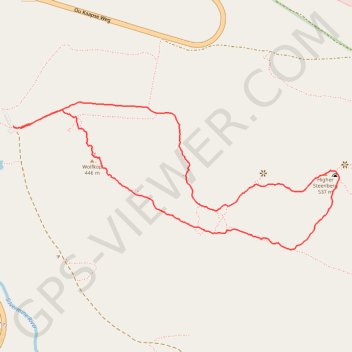
High Steenberg via Wolfkop
This relatively easy hike begins with a short but steep, unexposed scramble up to Wolfkop. From there, you follow a circular route that takes you past Steenberg Peak with panoramic views of the surrounding mountains, valleys, and the coastline in the distance.
- Distance: 3.5 Km
- Elevation gain: 241 m
- Maximum elevation: 535 m
- Elevation loss: 241 m
- Minimum elevation: 299 m
- Moving time: 1 h 23 m
- Moving speed: 2.5 Km/h
- Maximum speed: 6.2 Km/h
- Total time: 1 h 59 m
- Global speed: 1.8 Km/h
Interactive trail map
Trail profile
- Distance: 3.5 Km
- Elevation gain: 241 m
- Maximum elevation: 535 m
- Elevation loss: 241 m
- Minimum elevation: 299 m
- Moving time: 1 h 23 m
- Moving speed: 2.5 Km/h
- Maximum speed: 6.2 Km/h
- Total time: 1 h 59 m
- Global speed: 1.8 Km/h
About this trail
Name: High Steenberg via Wolfkop trail, distance, elevation, map, profile, GPS track
Start: A, Cape Town Ward 71, City of Cape Town, Western Cape, 7978, South Africa (-34.09161 18.42309)
End: A, Cape Town Ward 71, City of Cape Town, Western Cape, 7978, South Africa (-34.09164 18.42314)
Coordinates: -34.09590 18.42309 -34.09077 18.43677
Topography: City of Cape Town topographic map, elevation, terrain
Other hiking, mountain biking, running and outdoor activity trails
Click on a trail to view its statistics, map and profile.
Simon's Town - Cape Town
South Africa > Western Cape > City of Cape Town > Simon's Town
#Bike
Distance: 53.9 Km • Elevation gain: 1,127 m • Maximum elevation: 184 m
Klein-Tuinkop Loop Trail in Cape Floral Region Protected Areas
South Africa > Western Cape > City of Cape Town
Distance: 7.4 Km • Elevation gain: 345 m • Maximum elevation: 477 m