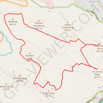
Kalk Bay Peak - Ridge Peak - St. James Peak - Muizenberg Peak
Interactive trail map
Trail profile
- Distance: 12.7 Km
- Elevation gain: 568 m
- Maximum elevation: 511 m
- Elevation loss: 565 m
- Minimum elevation: 265 m
About this trail
Name: Kalk Bay Peak - Ridge Peak - St. James Peak - Muizenberg Peak trail, distance, elevation, map, profile, GPS track
Start: A, Cape Town Ward 71, City of Cape Town, Western Cape, 7978, South Africa (-34.09163 18.42309)
End: A, Cape Town Ward 71, City of Cape Town, Western Cape, 7978, South Africa (-34.09163 18.42346)
Coordinates: -34.11483 18.42309 -34.09103 18.45898
Topography: City of Cape Town topographic map, elevation, terrain
Other hiking, mountain biking, running and outdoor activity trails
Click on a trail to view its statistics, map and profile.
Klein-Tuinkop Loop Trail in Cape Floral Region Protected Areas
South Africa > Western Cape > City of Cape Town
Distance: 7.4 Km • Elevation gain: 345 m • Maximum elevation: 477 m
Simon's Town - Cape Town
South Africa > Western Cape > City of Cape Town > Simon's Town
#Bike
Distance: 53.9 Km • Elevation gain: 1,127 m • Maximum elevation: 184 m
High Steenberg via Wolfkop
South Africa > Western Cape > City of Cape Town
This relatively easy hike begins with a short but steep, unexposed scramble up to Wolfkop. From there, you follow a circular route that takes you past Steenberg Peak with panoramic views of the surrounding mountains, valleys, and the coastline in the distance.
Distance: 3.5 Km • Elevation gain: 241 m • Maximum elevation: 535 m