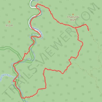
Guy Fawkes River Loop Hike from Chaelundi
- Distance: 24.8 Km
- Elevation gain: 929 m
- Maximum elevation: 1,013 m
- Elevation loss: 929 m
- Minimum elevation: 346 m
- Moving time: 4 h 10 m
- Moving speed: 5.9 Km/h
- Maximum speed: 13.5 Km/h
- Total time: 4 h 18 m
- Global speed: 5.8 Km/h
Interactive trail map
Trail profile
- Distance: 24.8 Km
- Elevation gain: 929 m
- Maximum elevation: 1,013 m
- Elevation loss: 929 m
- Minimum elevation: 346 m
- Moving time: 4 h 10 m
- Moving speed: 5.9 Km/h
- Maximum speed: 13.5 Km/h
- Total time: 4 h 18 m
- Global speed: 5.8 Km/h
About this trail
Name: Guy Fawkes River Loop Hike from Chaelundi trail, distance, elevation, map, profile, GPS track
Start: Escarpment Walking Track, New South Wales, Australia (-30.06763 152.33301)
End: Escarpment Walking Track, Clarence Valley Council, New South Wales, Australia (-30.06763 152.33297)
Coordinates: -30.10844 152.28004 -30.05137 152.33301