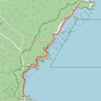
Murramarang South Coast Walk between Pretty Beach and Depot Beach
- Distance: 11.7 Km
- Elevation gain: 305 m
- Maximum elevation: 44 m
- Elevation loss: 303 m
- Minimum elevation: -1 m
- Moving time: 3 h 3 m
- Moving speed: 3.8 Km/h
- Maximum speed: 19.4 Km/h
- Total time: 3 h 40 m
- Global speed: 3.2 Km/h
Interactive trail map
Trail profile
- Distance: 11.7 Km
- Elevation gain: 305 m
- Maximum elevation: 44 m
- Elevation loss: 303 m
- Minimum elevation: -1 m
- Moving time: 3 h 3 m
- Moving speed: 3.8 Km/h
- Maximum speed: 19.4 Km/h
- Total time: 3 h 40 m
- Global speed: 3.2 Km/h
About this trail
Name: Murramarang South Coast Walk between Pretty Beach and Depot Beach trail, distance, elevation, map, profile, GPS track
Coordinates: -35.62850 150.32131 -35.56828 150.36707
Other hiking, mountain biking, running and outdoor activity trails
Click on a trail to view its statistics, map and profile.
Dalmeny - Murramarang National Park - Meroo National Park - Dolphin Point (Ulladulla)
Australia > New South Wales > Bodalla
#Bike #Murramarang #Meroo
Distance: 129.0 Km • Elevation gain: 1,932 m • Maximum elevation: 121 m