Thank you for supporting this site ❤️
Make a donation
Make a donation
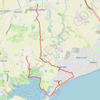
2026-05-24 MUNDHAM PAGHAM WALK
- Distance: 14.6 Km
- Elevation gain: 46 m
- Maximum elevation: 10 m
- Elevation loss: 40 m
- Minimum elevation: -2 m
- Moving time: 3 h 35 m
- Moving speed: 4.1 Km/h
- Maximum speed: 8.4 Km/h
- Total time: 5 h 4 m
- Global speed: 2.9 Km/h
Interactive trail map
Thank you for supporting this site ❤️
Make a donation
Make a donation
Trail profile
- Distance: 14.6 Km
- Elevation gain: 46 m
- Maximum elevation: 10 m
- Elevation loss: 40 m
- Minimum elevation: -2 m
- Moving time: 3 h 35 m
- Moving speed: 4.1 Km/h
- Maximum speed: 8.4 Km/h
- Total time: 5 h 4 m
- Global speed: 2.9 Km/h
Thank you for supporting this site ❤️
Make a donation
Make a donation
About this trail
Name: 2026-05-24 MUNDHAM PAGHAM WALK trail, distance, elevation, map, profile, GPS track
Coordinates: 50.76154 -0.76863 50.81590 -0.72448
Thank you for supporting this site ❤️
Make a donation
Make a donation
Other hiking, mountain biking, running and outdoor activity trails
Click on a trail to view its statistics, map and profile.
Walk from Chichester to Bognor
United Kingdom > England > West Sussex > Chichester
Distance: 18.5 Km • Elevation gain: 44 m • Maximum elevation: 20 m