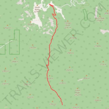
Sawmill Canyon
- Distance: 11.7 Km
- Elevation gain: 994 m
- Maximum elevation: 3,025 m
- Elevation loss: 51 m
- Minimum elevation: 2,052 m
- Moving time: 5 h 23 m
- Moving speed: 2.2 Km/h
- Maximum speed: 5.9 Km/h
- Total time: 20 h 9 m
- Global speed: 0.6 Km/h
Interactive trail map
Trail profile
- Distance: 11.7 Km
- Elevation gain: 994 m
- Maximum elevation: 3,025 m
- Elevation loss: 51 m
- Minimum elevation: 2,052 m
- Moving time: 5 h 23 m
- Moving speed: 2.2 Km/h
- Maximum speed: 5.9 Km/h
- Total time: 20 h 9 m
- Global speed: 0.6 Km/h
About this trail
Name: Sawmill Canyon trail, distance, elevation, map, profile, GPS track
Start: West Fork Trail, Socorro County, New Mexico, United States (33.91523 -107.16491)
End: Timber Peak Trail, Socorro County, New Mexico, United States (33.99037 -107.17302)
Coordinates: 33.91523 -107.17938 33.99183 -107.16487
Other hiking, mountain biking, running and outdoor activity trails
Click on a trail to view its statistics, map and profile.
Timber Peak Trail
United States > New Mexico > Socorro County
Distance: 8.5 Km • Elevation gain: 354 m • Maximum elevation: 3,167 m