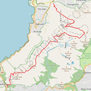
Table Mountain traverse from Kloof Corner to Suikerbossie via Maclear's Beacon
- Distance: 20.8 Km
- Elevation gain: 1,511 m
- Maximum elevation: 1,077 m
- Elevation loss: 1,605 m
- Minimum elevation: 162 m
- Moving time: 5 h 28 m
- Moving speed: 3.8 Km/h
- Maximum speed: 24.3 Km/h
- Total time: 5 h 47 m
- Global speed: 3.6 Km/h
Interactive trail map
Trail profile
- Distance: 20.8 Km
- Elevation gain: 1,511 m
- Maximum elevation: 1,077 m
- Elevation loss: 1,605 m
- Minimum elevation: 162 m
- Moving time: 5 h 28 m
- Moving speed: 3.8 Km/h
- Maximum speed: 24.3 Km/h
- Total time: 5 h 47 m
- Global speed: 3.6 Km/h
About this trail
Name: Table Mountain traverse from Kloof Corner to Suikerbossie via Maclear's Beacon trail, distance, elevation, map, profile, GPS track
Coordinates: -34.01139 18.35018 -33.94330 18.42642
Topography: Cape Town topographic map, elevation, terrain
Other hiking, mountain biking, running and outdoor activity trails
Click on a trail to view its statistics, map and profile.
Simon's Town - Cape Town
South Africa > Western Cape > City of Cape Town > Simon's Town
#Bike
Distance: 53.9 Km • Elevation gain: 1,127 m • Maximum elevation: 184 m
Route von Longmarket Street nach/zu Rhodesrylaan
South Africa > Western Cape > City of Cape Town > Cape Town
Distance: 12.3 Km • Elevation gain: 149 m • Maximum elevation: 114 m
Cape Town - Gun Run Trail 2023
South Africa > Western Cape > City of Cape Town > Cape Town
Distance: 17.4 Km • Elevation gain: 710 m • Maximum elevation: 521 m