Trans Catalina Trail (TCT)
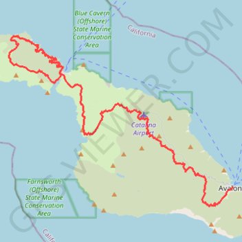
The Trans-Catalina Trail begins in Avalon, leaving the island’s lively harbor town to climb into the dry, rugged interior of Santa Catalina Island. The route passes Haypress Reservoir and Cape Canyon Reservoir before entering the Black Jack backcountry and continuing toward Catalina Airport, often known as the Airport in the Sky. Along this opening section, chaparral hillsides, open ridgelines, reservoir basins and broad Pacific views introduce the wild character of the island.
Beyond the airport, the trail crosses a quieter landscape of canyons, grassland, coastal scrub and mountain viewpoints before descending toward Little Harbor, one of the most memorable beach settings on the route. It then climbs again through exposed island terrain and drops toward Two Harbors, the small isthmus settlement set between the north-shore waters and Catalina Harbour. This central point marks the transition from the long interior traverse to the more maritime western loop.
From Two Harbors, the western loop is followed clockwise, first turning toward Catalina Harbour before crossing the rugged west end and returning along the north-facing coast. The route passes Parsons Landing, Emerald Bay, Howland’s Landing, Big Geiger Cove, Little Geiger Cove, Cherry Cove and Fourth of July Cove before closing the loop back at Two Harbors. This final section brings together sheltered coves, steep coastal slopes, Pacific seascapes and protected backcountry habitats where bison, Catalina Island foxes, seabirds and bald eagles may be seen.
#Hiking #Loop #TCT #Island #Catalina #Nature #Mountain #Forest #Sea #Pacific #Ocean #Lake #Coast #Cove #Beach #Wildlife
- Distance: 62.3 Km
- Elevation gain: 2,826 m
- Maximum elevation: 531 m
- Elevation loss: 2,820 m
- Minimum elevation: 1 m
Interactive trail map
Trail profile
- Distance: 62.3 Km
- Elevation gain: 2,826 m
- Maximum elevation: 531 m
- Elevation loss: 2,820 m
- Minimum elevation: 1 m
About this trail
Name: Trans Catalina Trail (TCT) trail, distance, elevation, map, profile, GPS track
End: Two Harbors, Los Angeles County, California, United States (33.43975 -118.49933)
Coordinates: 33.32683 -118.55404 33.47278 -118.32392
Other hiking, mountain biking, running and outdoor activity trails
Click on a trail to view its statistics, map and profile.
Hiking trail near Avalon, California
United States > California > Los Angeles County
Distance: 5.3 Km • Elevation gain: 87 m • Maximum elevation: 426 m