Thank you for supporting this site ❤️
Make a donation
Make a donation
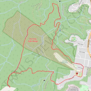
Morning Run
- Distance: 10.7 Km
- Elevation gain: 356 m
- Maximum elevation: 213 m
- Elevation loss: 357 m
- Minimum elevation: 50 m
- Moving time: 1 h 20 m
- Moving speed: 8.0 Km/h
- Maximum speed: 12.6 Km/h
- Total time: 1 h 21 m
- Global speed: 7.8 Km/h
Interactive trail map
Thank you for supporting this site ❤️
Make a donation
Make a donation
Trail profile
- Distance: 10.7 Km
- Elevation gain: 356 m
- Maximum elevation: 213 m
- Elevation loss: 357 m
- Minimum elevation: 50 m
- Moving time: 1 h 20 m
- Moving speed: 8.0 Km/h
- Maximum speed: 12.6 Km/h
- Total time: 1 h 21 m
- Global speed: 7.8 Km/h
Thank you for supporting this site ❤️
Make a donation
Make a donation
About this trail
Name: Morning Run trail, distance, elevation, map, profile, GPS track
Coordinates: -33.69639 151.06938 -33.67320 151.09461
Thank you for supporting this site ❤️
Make a donation
Make a donation
Other hiking, mountain biking, running and outdoor activity trails
Click on a trail to view its statistics, map and profile.