Thank you for supporting this site ❤️
Make a donation
Make a donation
Tracked with OSMTracker for Android™
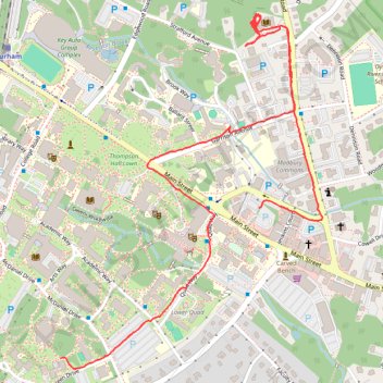
walking around durham, story path at the Durham public library
- Distance: 3.4 Km
- Elevation gain: 33 m
- Maximum elevation: 30 m
- Elevation loss: 19 m
- Minimum elevation: 11 m
- Moving time: 49 m 28 s
- Moving speed: 4.1 Km/h
- Maximum speed: 12.9 Km/h
- Total time: 58 m 18 s
- Global speed: 3.5 Km/h
Interactive trail map
Thank you for supporting this site ❤️
Make a donation
Make a donation
Trail profile
- Distance: 3.4 Km
- Elevation gain: 33 m
- Maximum elevation: 30 m
- Elevation loss: 19 m
- Minimum elevation: 11 m
- Moving time: 49 m 28 s
- Moving speed: 4.1 Km/h
- Maximum speed: 12.9 Km/h
- Total time: 58 m 18 s
- Global speed: 3.5 Km/h
Thank you for supporting this site ❤️
Make a donation
Make a donation
About this trail
Name: Tracked with OSMTracker for Android™ trail, distance, elevation, map, profile, GPS track
Coordinates: 43.13120 -70.93426 43.14020 -70.92514
Thank you for supporting this site ❤️
Make a donation
Make a donation
Other hiking, mountain biking, running and outdoor activity trails
Click on a trail to view its statistics, map and profile.
University of New Hampshire College woods bike
United States > New Hampshire > Strafford County > Durham
Distance: 6.3 Km • Elevation gain: 72 m • Maximum elevation: 36 m