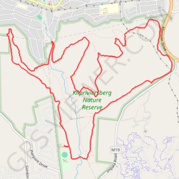
Klipriviersburg Nature Reserve loop
- Distance: 17.3 Km
- Elevation gain: 622 m
- Maximum elevation: 1,787 m
- Elevation loss: 622 m
- Minimum elevation: 1,548 m
- Moving time: 2 h 10 m
- Moving speed: 7.9 Km/h
- Maximum speed: 11.8 Km/h
- Total time: 2 h 17 m
- Global speed: 7.6 Km/h
Interactive trail map
Trail profile
- Distance: 17.3 Km
- Elevation gain: 622 m
- Maximum elevation: 1,787 m
- Elevation loss: 622 m
- Minimum elevation: 1,548 m
- Moving time: 2 h 10 m
- Moving speed: 7.9 Km/h
- Maximum speed: 11.8 Km/h
- Total time: 2 h 17 m
- Global speed: 7.6 Km/h
About this trail
Name: Klipriviersburg Nature Reserve loop trail, distance, elevation, map, profile, GPS track
Coordinates: -26.30606 28.00014 -26.27954 28.03514
Topography: Johannesburg topographic map, elevation, terrain
Other hiking, mountain biking, running and outdoor activity trails
Click on a trail to view its statistics, map and profile.
Klipriviersberg Nature Reserve loop
South Africa > Gauteng > City of Johannesburg Metropolitan Municipality > Johannesburg
Distance: 13.7 Km • Elevation gain: 500 m • Maximum elevation: 1,787 m
Klipriviersburg Nature Reserve Loop
South Africa > Gauteng > City of Johannesburg Metropolitan Municipality > Johannesburg
Distance: 19.8 Km • Elevation gain: 681 m • Maximum elevation: 1,787 m